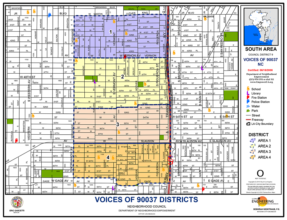
North: South side of Martin Luther King Jr. Boulevard, between Southbound 110 Freeway on the east, continuing west to the east side of Normandie Avenue.
South: West on the north side of Gage Avenue from Southbound 110 Freeway to Vermont Avenue, continuing north on Vermont Avenue to 62nd Street, then west on 62nd Street to the south side of Normandie Avenue.
East: Southbound 110 Freeway from Martin Luther King Jr. Blvd. on the north and Gage Ave. on the south.
West: South on the east side of Normandie Avenue from Martin Luther King Jr. King Boulevard to the north side of 62nd Street.
Shared space boundaries: The Exposition Park Complex or Exposition Blvd. on the North; Figueroa Street on the East; Vermont Avenue on the West, and Martin Luther King, Jr. Blvd. on the South.
The Council’s boundaries are further broken into four areas, with four elected representatives for each.
North: South side of Martin Luther King Jr. Boulevard, between Southbound 110 Freeway on the east, continuing west to the east side of Normandie Avenue. South: Vernon Ave (north side of street), between Southbound 110 Freeway on the east, continuing west to the east side of Normandie Ave. East: Flower Street, between Martin Luther King, Jr., Blvd on the North and Gage Street on the South. West: Normandie Ave (east side of street), between Martin Luther King, Jr., Blvd on the north and Gage Street on the south.
North: Vernon Ave. (south side of street), between Southbound 110 Freeway on the east, continuing west to the east side of Normandie Avenue. South: 52nd Street, between Southbound 110 Freeway on the east, continuing west to the east side of Normandie Ave. East: Southbound 110 Freeway, between Martin Luther King, Jr., Blvd on the North and Gage Street on the South. West: Normandie Ave (east side of street), between Martin Luther King, Jr., Blvd on the north and Gage Street on the south.
North: 53rd Street, between Southbound 110 Freeway on the east, continuing west to the east side of Normandie Avenue. South: Slauson Ave (north side of street), between Southbound 110 Freeway on the east, continuing west to the east side of Normandie Ave. East: Southbound 110 Freeway, between Martin Luther King, Jr., Blvd on the North and Gage Street on the South. West: Normandie Ave (east side of street), between Southbound 110 Freeway on the east, continuing west to the east side of Normandie Ave.
North: Slauson Ave (south side of street), between Southbound 110 Freeway on the east, continuing west to the east side of Normandie Avenue.
South: West on the north side of Gage street from Southbound 110 Freeway to Vermont Avenue, continuing north on Vermont Avenue to 62nd Street, then west on 62nd Street to the South side of Normandie Ave.
East: Southbound 110 Freeway between Martin Luther King, Jr., Blvd on the North and Gage Street on the South.
West: Normandie Ave (east side of street), between Martin Luther King, Jr., Blvd on the north and Gage Street on the south.

![]()
![]()
![]()
![]()
The Voices Neighborhood Council is made up of individuals from our community who
are interested in improving and maintaining the quality of life of the stakeholders of Voices.
News Agendas/Minutes Photo Gallery Bylaws Neighborhood Proposed Grants Contact
Accessibility Privacy Policy
Make a choice. Share your VOICE.

 MENU
MENU